The 3D model of the Düwelsteene was created by taking photos (Nikon digital SLR camera) of the megalithic tomb from every possible direction and angle. These photographs were also photogrammetrically rectified to correct any geometric distortion in the images. The images were then calculated and used to create a three-dimensional mesh in the software Agisoft Metashape.
Since it is a large archaeological monument and the tomb was to be digitized in high quality, not only were many images taken of the tomb itself, but every single stone was captured from all possible positions. Thus, hundreds of images were taken of the tomb and of each individual megalith, ensuring that the images overlapped. This is necessary because from these overlapping parts of the photographs taken side by side, the images can be merged and characteristic structures can be recognized, leading to a pixel-precise structure.
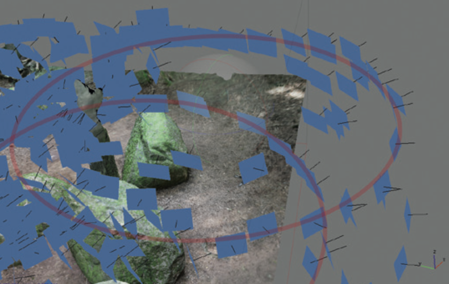
Structure from Motion as part of the digitisation of the Großen Sloopsteene (Image: LWL-Altertumskommission für Westfalen/Klinke)
The photogrammetry software, in this case Agisoft Metashape, allows the determination of capture positions and object structures by analyzing optical shifts, such as edges, fracture surfaces, or crack lines, based on the compared, inserted photographs. After processing, the initial calculation results are visualized in the form of a rudimentary point cloud, technically referred to as a "Sparse Cloud".
A further algorithmic step transforms this Sparse Cloud into a denser point cloud, the "Dense Cloud". During this calculation, all individual images are subjected to depth filtering to insert additional measurement points between the existing ones of the Sparse Cloud. This is not based simply on interpolation, but includes the consideration of relief changes between the measurement points of the Sparse Cloud to ensure increased accuracy. The resulting Dense Clouds reflect the current state of maximum surveying accuracy and are comparable to the data results of terrestrial laser scanners. One advantage is that each measurement point in the Dense Cloud already has a color value, unlike laser scans, which require additional color information from supplementary photographs.
In the subsequent process step, the photogrammetrically determined measurement points are triangulated. In this procedure, three measurement points are always connected, creating triangular surfaces. Usually, the spatially closest points are used to ensure optimal accuracy. The resulting triangular surfaces can be modified for further triangulations, primarily used to close gaps in the point clouds. This triangulation procedure results in a so-called "Mesh" model with the visual character of a three-dimensional wireframe model.
In a final computational step, a texture, similar to a covering skin, is applied over the Mesh model. This gives the 3D model its photorealistic appearance. The underlying texture comes from the photogrammetrically corrected individual photographs from the initial processing step. In contrast to pure shape data, which only represents the morphology and relief, this texture integrates additional visual information such as color nuances, light reflections, and shadow gradients that were captured during the documentation phase.
The workflow for digitizing the megalithic tomb was applied by the Altertumskommission für Westfalen for all previously digitized megalithic tombs, such as the Großen Sloopsteene. Each unit (a single megalith or a small group of megaliths located directly next to each other) is photographed. These individual units are then entered separately into the computer software Agisoft Metashape and converted into a rough 3D point cloud. Once a unit has been digitized and transformed into a rough point cloud, the next unit (the next adjacent megalith) is added to the software. With each added megalith, the entire megalithic tomb is gradually converted into a point cloud (Klinke 2021).
After the complete rough point cloud has been created, Metashape is used to compute and create a dense point cloud, which is then converted into a 3D mesh with an added photorealistic texture. The point cloud of the Düwelsteene consists of over 378 million measurement points. With this high-quality and high-resolution 3D model, the Düwelsteene is digitized in a quality that can assist in monument conservation and illustrate any movement or minimal destruction of the megalithic tomb in the future, as it was precisely measured through image-based modeling.
- - - - - - - - - - - - - - - - - - - - - - - - - - -
Sources and further reading: